Central U.S. braces for tornadoes and flash flooding as powerful storm approaches
Millions of people across a large swath of the United States from Texas to Michigan are expected to face heavy rain, high winds, hail, flooding and other dangerous weather as a major storm system sweeps in starting Wednesday.
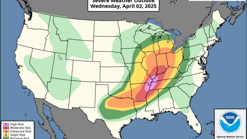
The National Weather Service warned in guidance issued Wednesday that the “multi-day catastrophic and potentially historic” event will produce a “barrage of life-threatening” conditions, including powerful tornadoes and widespread flash flooding.
An NWS map shows Memphis and Little Rock at high and moderate risk for severe weather, respectively, while other cities including St. Louis, Cincinnati and Louisville are also expected to see inclement conditions.
Kentucky Gov. Andy Beshear declared a state of emergency ahead of the storm on Wednesday, saying his state was facing “some of the most serious weather threats I’ve seen.”
The mayor of Little Rock, Ark., announced via social media that the city had cancelled the weekly test of its emergency warning sirens, telling residents that any sirens they heard on Wednesday would actually indicate an imminent tornado.
The NWS says areas most at risk for tornadoes on Wednesday include northeastern Arkansas, western Tennessee, western Kentucky, southern Illinois and southeastern Missouri. Some tornadoes may even reach the level of an EF3, which is characterized by estimated wind gusts between 136-165 miles per hour.
Outside of that high-risk region, other parts of those states as well as portions of Indiana, Ohio, Mississippi and Texas could see less severe tornadoes, wind gusts and hail.
NWS forecasters also said intense thunderstorms will hit large stretches of the Great Lakes region, Appalachia and Texas.
Some places within that region could see historic rainfall totals as high as 15 inches through the weekend. The storm front will stall out over the area on Thursday, potentially dropping six inches of rain over a two-day period.
Repeated bouts of rainfall could saturate the soil and worsen flooding, forecasters said. “This isn’t routine,” the NWS Memphis office warned of the expected flooding. “This is a rare, high-impact, and potentially devastating event.”
People in the storm’s path could experience “long duration and severe disruptions to daily life” as a result of the expected rainfall and flooding, the NWS added.

Dozens presumed dead in fire at Swiss Alps bar during New Year’s celebration
Dozens of people are presumed dead and about 100 injured, most of them seriously, following a fire at a Swiss Alps bar during a New Year's celebration, police said Thursday.

Crypto soared in 2025 — and then crashed. Now what?
For most of 2025, cryptocurrencies such as bitcoin surged as President Trump vowed to make the U.S. a crypto leader. But now, a severe sell-off has shaken the sector.

Warren Buffett officially retires as Berkshire Hathway’s CEO
The legendary 95-year-old investor spent decades building his company into one of the world's largest and most powerful. Now Greg Abel is taking it over.

Zohran Mamdani sworn in as New York City mayor, capping historic rise
Mayor Zohran Mamdani took the oath of office in New York City after midnight Thursday. The city's first Muslim mayor, a member of the Democratic Socialists of America, has promised to focus on affordability and fairness.
Rising from the ashes, a symbol of hope at the Rose Parade
Survivors of the Eaton and Palisades Fires find healing and community working on a Rose Parade float to honor the lives and communities lost in last year's wildfires.

The history behind the NYC subway station chosen for Mamdani’s swearing-in
The city shut down the station in 1945 on New Year's Eve. Eighty years later, it's a symbolic venue choice for the incoming mayor's private swearing-in ceremony.