Pilot Project Aims to Make Trails More Accessible
Last month, Sunny Workman and Missy Kittrell were on the trails at Oak Mountain State Park south of Birmingham. They’re ultra trail runners and are at the park four or five days a week. Workman says they came upon a man on the trail.
“[He was] pushing what appeared to be a stroller,” says Workman. “We just looked at each other like, oh no, he’s lost. He really doesn’t know what he’s doing.”
But he wasn’t lost and it wasn’t exactly a stroller. He pushed it like a lawnmower. It had gadgets attached to the frame and a laptop between the handles.
“When we saw all the equipment we were like, why is Google Earth out here?” says Workman.
The man pushing the stroller, Nathan Tolbert, wasn’t from Google either. He’s with Beneficial Designs Inc. It’s a firm in Nevada.
He was carefully mapping the trail, but not merely logging the route. Tolbert records information such as the grade, elevation changes, the width of the pathway, the surface hardness, and notable obstructions.
It’s tough work as Tolbert and a partner push the equipment over 38 miles of trails.
“Because you have to muscle this thing around and get it up and down and hold it and control your laptop at the same time,” says Tolbert. “And then with the cart when you’re on rugged terrain, trying to muscle that thing up and down and going over rocks. It ends up being a full body workout.”
Tolbert’s effort is part of a pilot project led by the Birmingham-based Lakeshore Foundation. The organization promotes physical activity among physically disabled individuals. This detailed information about the trails could be very helpful to those who do use a wheelchair or have limited mobility.
People such as Karin Korb.
She’s a policy coordinator at the Lakeshore Foundation and loves being outdoors. She’s also a wheelchair user. Korb says there are extra considerations she has when going on a hike.
“What’s the terrain going to be like? Can I access it with my chair? Is it going to be super hilly? Or what’s the slope? Is it going to be rocky? Is it going to be flat? Is it going to be sandy?” says Korb. “Because if I know, then I can be more prepared.”
For instance, she can switch the tires on her chair to ones that are hard, not filled with air. If she knows a trail isn’t wide enough to accommodate her chair, she can plan accordingly.
“If there was a sign that says, hey, this is a two-point-five percent grade, then I know that it is going to be what we consider fairly flat,” says Korb. “I’m cool with that.”
That’s where this project leads. All that mapping information will be distilled down into signs that are kind of like a nutritional label for each trail. It’s a lot more detail and a lot more helpful than simple descriptions of easy, medium or difficult and all in an effort to make the trails at Oak Mountain more accessible.
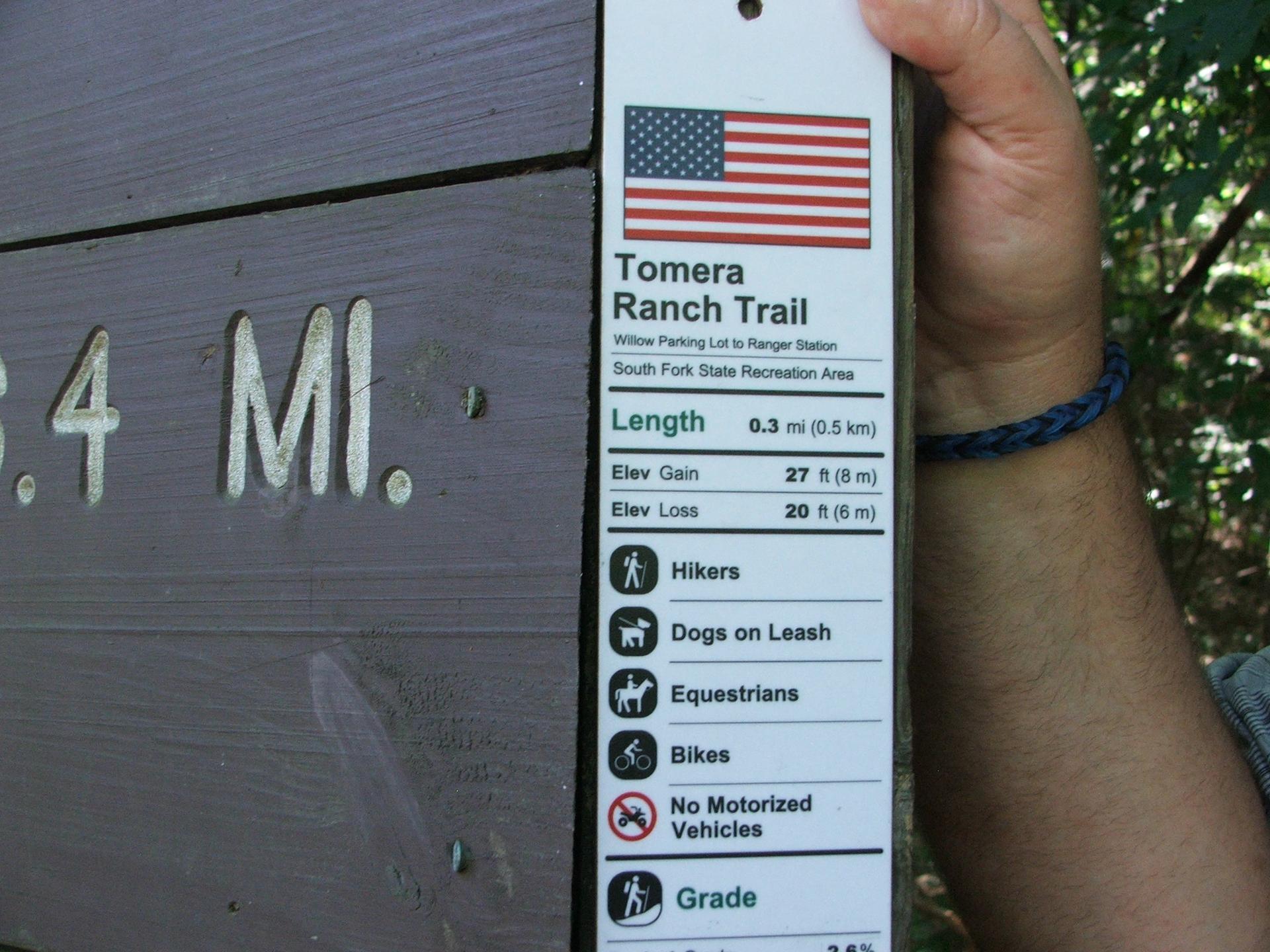
La'Nissi Brown,WBHM
A sample sign
The focus may be those with physical disabilities but organizers say the information is helpful for anyone planning a hike. Nathan Tolbert says his requirements are different from a wheelchair user but still can be informed by the trail mapping.
“When I go out with my son, I want somewhere that’s short and has maybe a destination along the way, a creek passing, not too steep and not too soft,” says Tolbert. “Otherwise, he’s going to be tired and I’m going to be carrying him.”
Ultra trail runners Missy Kittrell and Sunny Workman say they know the park pretty well but it will be helpful to have accurate measurements for the trail.
The $48,000 dollar project is supported by Lakeshore along with grants from the federal government and the Munson Foundation, a group that’s given to environmental causes. The money goes to purchase mapping equipment, plus a program to train people in Alabama so other trails can be mapped.
And those trail nutritional labels for Oak Mountain State Park, a.k.a. the signs, are expected to go up next month.


How this long-lost Chinese typewriter from the 1940s changed modern computing
The concepts in the MingKwai typewriter underlie how Chinese, Japanese and Korean are typed today. The typewriter, patented in 1946, was found last year in an upstate New York basement.

North Korea has a new luxury beach resort. But the country isn’t open to most tourists
North Korean leader Kim Jong Un said he wants the luxury resort on the eastern seacoast to become a "world destination," but the country has been reluctant to allow in foreign tourists.

Mariska Hargitay walks a fine line in ‘My Mom Jayne’
It's natural to feel some skepticism when a celebrity makes a documentary about their own family. But Law & Order star Mariska Hargitay' tells a story that is both effective and empathetic.

Ukraine says it struck a Russian airbase as Russia sent drones into Ukraine
Ukraine said it struck a Russian airbase on Saturday, while Russia continued to pound Ukraine with hundreds of drones overnight, dashing hopes for a breakthrough in efforts to end the war.

‘Buy now, pay later’ purchases can now affect your credit score. Here’s what that means
Services that split up payments into installments are increasingly popular, especially among young and low-to-middle income shoppers. But now the FICO credit scoring company will be tracking that debt.

Will Trump’s megabill help Democrats win the House?
Democrats feel that Trump's tax and spending bill gives them an opening ahead of the 2026 midterms. But if they want to win back the House, they're going to have to get their own house in order first.