Hurricane Erin brings flooding to parts of Outer Banks as it pivots from East Coast
Hurricane Erin is slowly moving away from the U.S. eastern seaboard, but not before grazing North Carolina, where the storm cut off some road access in the Outer Banks and brought rain, storm surge and dangerous rip currents to coastal communities in the state. It’s likely to cause coastal flooding to other parts of the mid-Atlantic and Northeast in the coming hours.
In its 2 p.m. ET advisory on Thursday, the National Hurricane Center (NHC) in Miami said the center of the Category 2 storm, which is packing sustained winds of nearly 100 miles per hour with higher gusts, is at about 285 miles east of Cape Hatteras.
A storm surge warning remains in effect from Cape Lookout to Duck, N.C., indicating a life-threatening risk of coastal flooding from rising waters. A tropical storm warning is in place from Beaufort Inlet, N.C., to Chincoteague, Va. A tropical storm warning has also been issued for Bermuda.
Wind gusts with tropical storm force are likely in the mid-Atlantic and southern New England coast through early Friday, forecasters said.
Despite not making landfall, forecasters have pointed out that Erin’s unusual size — with tropical-storm-force winds affecting a more than 600-mile diameter area in the storm’s path — is unusual.
As the western edge of the storm raked the Outer Banks, North Carolina Gov. Josh Stein on Wednesday gave his own brief but very clear warning. Because of the high waves and powerful rip current, “no one should be in the ocean,” he said.
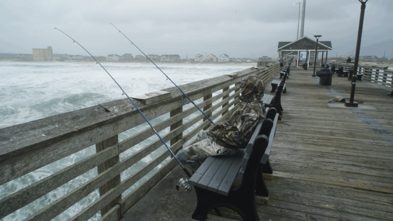
The Outer Banks is a vulnerable stretch of barrier islands that jut into the Atlantic, but it’s no stranger to hurricanes. Huge waves lapped at beachfront homes built on stilts and the ferry connection between Ocracoke Island and the mainland was cut off.
The Island Free Press, which covers the Outer Banks, reported that Thursday morning’s high tide brought “extreme ocean overwash” to northern Buxton, the north of Hatteras Village, and northern Ocracoke Island. It said flooding had also inundated Hatteras Village.
“It’s pretty par for the course living out here,” Leslie Coleman, a resident of the Outer Banks, was quoted by WAVY as saying. “It’s certainly not one of the worst storms we’ve seen, but it’s got the waves coming up a little higher, eating at a little bit of our dunes.”
In a post on Facebook Thursday morning, Tideland Electric Membership Corporation, a co-op that provides power to the Outer Banks, said there was no loss of electricity to Ocracoke as a result of the storm. “Our crews are making their way to the north end of the island to inspect our infrastructure,” it said.
While Erin is moving northeast and away from the North Carolina coast on Thursday, another significant round of ocean overwash is expected with Thursday evening’s high tide.
More than 2,000 people — residents and vacationers — heeded evacuation orders for Ocracoke and Hatteras islands earlier.
The storm surge breached protective sand dunes overnight, cutting off Highway 12, the only main road out. “Deep sand, water and debris continue to cover the roadway,” Dare County’s government said in a social media post on Thursday.
The National Weather Service is warning of an ongoing storm surge up to 4 feet high in the Outer Banks for Thursday night.
Melinda Meadows, property manager at the Cape Hatteras Motel in Buxton, told WRAL that walls were ripped out and sand barriers have disappeared.
It’s been less than a year since North Carolina endured Hurricane Helene, one of the most devastating hurricanes in its modern history, which tore through the western part of the state. Helene caused at least 250 deaths.
The NHC says Erin is now turning northeast, away from the East Coast, and increasing its forward momentum, moving over the western Atlantic between the U.S. and Bermuda through Friday. Forecasters say it will gradually weaken during the next couple of days before falling below the threshold for a tropical storm by Saturday.
Across East Coast beaches from Florida to Maine there is a high potential for rip currents on Thursday, forecasters said, and warned potential swimmers to stay out of the water.

Pentagon shifts toward maintaining ties to Scouting
Months after NPR reported on the Pentagon's efforts to sever ties with Scouting America, efforts to maintain the partnership have new momentum
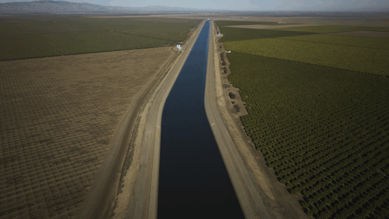
Why farmers in California are backing a giant solar farm
Many farmers have had to fallow land as a state law comes into effect limiting their access to water. There's now a push to develop some of that land… into solar farms.

Tariffs cost American shoppers. They’re unlikely to get that money back
After the Supreme Court declared the emergency tariffs illegal, the refund process will be messy and will go to businesses first.

Every business wants your review. What’s with the feedback frenzy?
Customers want to read reviews and businesses need reviews to attract customers. But the constant demand for reviews could be creating a feedback backlash, experts say.
Civil rights leaders say the racial progress Jesse Jackson fought for is under threat
Activists say racial progress won by the Rev. Jesse Jackson is under threat, as a new generation of leaders works to preserve hard-fought civil rights gains.
‘Get back to integrity’: Oklahoma’s Kevin Stitt on Republicans after Trump
NPR's Steve Inskeep asks Oklahoma Gov. Kevin Stitt about his spat with President Trump, immigration and the future of the Republican Party.