Latest Birmingham Area Weather Related Updates
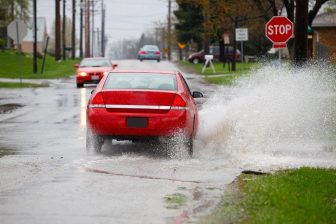
WBHM checked in with several law enforcement agencies earlier today for tips to lessen the risks of accidents when driving in wet or unpredictable conditions.
April 5, 2017, 1:25 p.m.

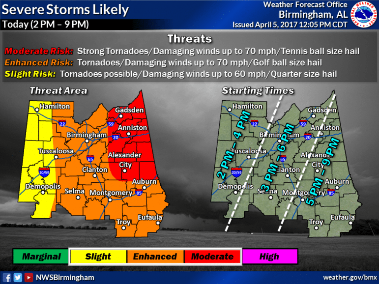
The National Weather Service released a new severe weather threat graphic at noon. A good portion of our listening area remains under an enhanced risk according to the graphic, with strong tornadoes still possible across eastern and northeastern portions of Central Alabama. The Weather Service is asking residents in the identified areas to not let their guard down, “as we’re going to likely see more severe storms developing from 2 p.m. through this evening,” according to a post to their fan page on Facebook.
April 5, 2017, 1:08 p.m.
The latest from the National Weather Service in Birmingham:
SVR TSTM WARNING for Shelby Co until 1:15pm – Large Hail & Damaging winds main threat. Headed NE. #alwx pic.twitter.com/Me1MzyuzKp
— NWS Birmingham (@NWSBirmingham) April 5, 2017
Sherrel Stewart spoke with Shelby County Emergency Management Supervisor Hub Harvey this morning by telephone. He says while he has not had reports of storm damage in that county this morning, his office is on alert for potential problems later. Harvey also has words of caution for area residents. “We just want to make sure that people are staying very weather aware, because the biggest chance of severe weather is going to be late this afternoon, like after 2 o’clock until 7. Eve n if the sun comes out we’re not out of danger.” Four storm shelters currently are open in Shelby County.
- 107 Mildred Street, Columbiana, directly behind the police station and City Hall in downtown Columbiana;
- 5384 Highway 62, Vincent, east of Vincent at the intersection County Road 62 and Gorman Park Road;
- 4175 County Rd. 22, Montevallo, behind West Shelby Fire Department on County Road 22;
- Westover Community Storm Shelter, 3312 Westover Road, Westover.
April 5, 2017, 11 a.m.
The National Weather Service in Birmingham revised the list of counties under a tornado watch they first announced earlier this morning.
We’ve trimmed a few more counties from the current watch, but once again this IS NOT AN ALL CLEAR. More storms coming this afternoon. #alwx pic.twitter.com/vzSPi8GVK4 — NWS Birmingham (@NWSBirmingham) April 5, 2017
The National Weather Service in Birmingham had issued a Tornado Watch for a significant portion of our listening area until 12 p.m. Central Time.
This followed Governor Robert Bentley issuing a State of Emergency for all of Alabama counties at 6 p.m. Tuesday evening in preparation for severe weather. As previously reported, the declaration will remain in effect until the threats have passed.
April 5, 2017, 10:45 a.m.
Reporters’ notebook: The Olympics closing ceremony is way more fun than you’d think
Olympics opening ceremonies tend to get more love than their closing counterparts. But a pair of NPR reporters who watched both in Italy left with a newfound appreciation for the latter.
Northeast readies for a major winter storm, with blizzard warnings in effect
New Jersey through Massachusetts could see 2 feet of snow. New York City's mayor said the city had not "seen a storm like this in a decade."
Mexican army kills leader of Jalisco New Generation Cartel, official says
The Mexican army killed the leader of the powerful Jalisco New Generation Cartel, Nemesio Rubén Oseguera Cervantes, "El Mencho," in an operation Sunday, a federal official said.
Ukraine’s combat amputees cling to hope as a weapon of war
Along with a growing number of war-wounded amputees, Mykhailo Varvarych and Iryna Botvynska are navigating an altered destiny after Varvarych lost both his legs during the Russian invasion.
University students hold new protests in Iran around memorials for those killed
Iran's state news agency said students protested at five universities in the capital, Tehran, and one in the city of Mashhad on Sunday.
Pakistan claims to have killed at least 70 militants in strikes along Afghan border
Pakistan's military killed at least 70 militants in strikes along the border with Afghanistan early Sunday, the deputy interior minister said.


