

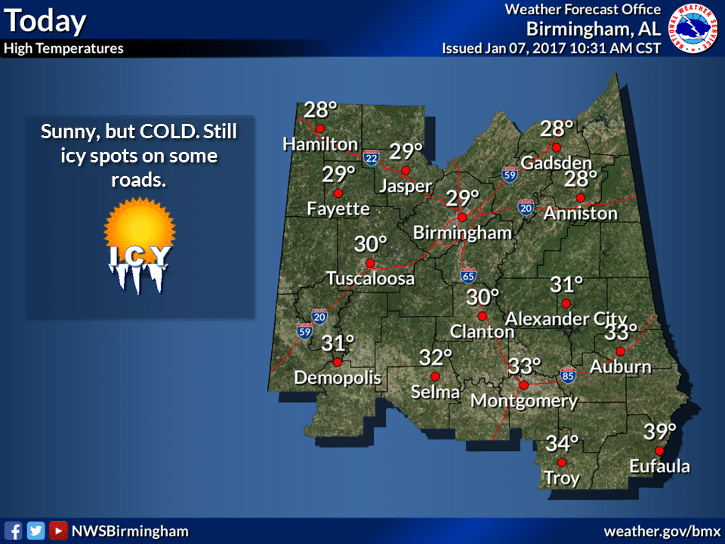
Sunny and cold today, with highs in the upper 20s to low 30s. Precipitation has stopped, but icy roads have been reported across much of Central Alabama. Travel still isn’t advised in many areas, the National Weather Service says. For live traffic camera feeds of roads and traffic information, visit ALGO Traffic.
-January 7 at 11:54 a.m.
______________________________________________________________________________________________________________________________
The National Weather Service is advising folks to stay off the roads. Snow is accumulating across Central Alabama. City roads in Vestavia Hills, Helena, Anniston, and Talladega have been closed due to icy conditions. The Jefferson County Sheriff’s Office is getting reports of icy roads. Temperatures are below freezing in many parts of the region.
-January 6 at 6:51 p.m.
______________________________________________________________________________________________________________________________
Look for more sleet and snow than initially expected throughout Central Alabama. The National Weather Service forecasts mostly sleet accumulations. In Birmingham, freezing rain and sleet are expected from 1 p.m. to 4 p.m., with less than a half-inch accumulation. Look for snow after 10 p.m., with accumulations of about an inch. Across central and eastern parts of Central Alabama on Friday into Saturday, the National Weather Service forecasts sleet and snow accumulations of 2 inches or more. Travel will be hazardous.
January 6 at 12:45 p.m.
______________________________________________________________________________________________________________________________
The area’s winter storm warning has been expanded, with snow, sleet, and freezing rain expected in the forecast today. The National Weather Service projects travel difficulties for the following cities: Gadsden, Anniston, Centre, Heflin, Tuscaloosa, Birmingham, Hoover, Pell City, Moody, Talladega, Sylacauga, Ashland, Roanoke, Greensboro, Moundville, Marion, Clanton, Rockford, Alexander City, Valley, and Lanett. Expect accumulations of 1 to 3 inches of snow and sleet, according to the National Weather Service, likely in the afternoon and evening hours.
-January 6 at 8:44 a.m.
______________________________________________________________________________________________________________________________
A winter weather advisory remains in effect for Central Alabama through 9 a.m. Saturday, according to the National Weather Service. Early Friday morning, expect temperatures to drop to the upper 20s and lower 30s. Accumulated snow and sleet are in the forecast for areas along and north of I-20.
-January 5 at 11:14 p.m.
_____________________________________________________________________________________________________________________________
The National Weather Service reports freezing isn’t likely tonight. Here’s the tweet from @NWSBirmingham, posted at 7:46 p.m.: Light showers making their way through Central AL tonight. Temps still above freezing, so should remain all liquid until tomorrow AM. #alwx
Light showers making their way through Central AL tonight. Temps still above freezing, so should remain all liquid until tomorrow AM. #alwx pic.twitter.com/nYn3AMW19r
— NWS Birmingham (@NWSBirmingham) January 6, 2017
-January 5 at 9:33 p.m.
______________________________________________________________________________________________________________________________
The Birmingham area is under a winter weather advisory until 9 a.m. Saturday.
Governor Robert Bentley on Thursday issued a State of Emergency effective 7:00 a.m. Friday for all Alabama counties in preparation for potential severe winter weather.
The National Weather Service expects a storm system to develop Friday morning through Saturday morning. The places seeing the greatest impact will be along and north of I-20. Snow accumulations of one-half-to-two- inches are possible along that corridor, including Tuscaloosa, the Birmingham Metro area, and spots north.
In a winter weather advisory, snow is expected to cause travel difficulties. Snow will likely cover the roads and there might be limited visibility. Drive with caution.
For a list of school closings click HERE.
-January 5 at 4:35 p.m.